Severe Weather, Tornadoes Possible Today Across East Texas
12:30pm
Tornado Warning for Tyler and Jasper Counties until 1pm.
AT 1226 PM CST...NATIONAL WEATHER SERVICE METEOROLOGISTS DETECTED A
  SEVERE THUNDERSTORM CAPABLE OF PRODUCING A TORNADO NEAR FRED...
  MOVING NORTHEAST AT 45 MPH.

* THE TORNADO WILL BE NEAR...
  SPURGER BY 1235 PM CST...
  MT. UNION BY 1240 PM CST...
  MAGNOLIA SPRINGS AND TOWN BLUFF BY 1245 PM CST...
  JASPER BY 100 PM CST...
11:30am
The National Weather Service has issued another severe thunderstorm warning for Tyler and Jasper counties until 12:30. Get all the details about the warning at this link.
10:55am
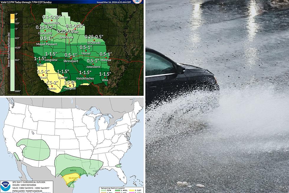
A number of severe thunderstorm warnings are active across the East Texas area. Persons in Shelby, San Augustine, Sabine, Tyler, Jasper, and Eastern Polk counties can expect damaging winds, heavy rains, and possible hail between now and noon. Keep in mind that a tornado watch is also in effect across the East Texas area.
10:30am
The National Weather Service has now issued a severe thunderstorm warning for Polk and eastern Trinity counties until 11 this morning. Severe storms are moving over the Highway 59 corrider from Corrigan to Shepherd. More details at this link.
10:00am
The National Weather Service has now issued a severe thunderstorm warning for Angelina, Nacogdoches, and San Augustine Counties until 10:45. Severe storms are moving into the Lufkin and Nacogdoches area and they continue to move northeast at 55mph. Winds in excess of 60mph can be expected. More details at this link.
9:45am
The National Weather Service has now issued a severe thunderstorm warning for northwestern Nacogdoches and Cherokee counties until 10:30. A line of severe storms with winds in excess of 60mph is moving through Cherokee County with the worst storms near the town of Forest, south of Rusk. Get more details at this link.
9:30am
The National Weather Service has issued a severe thunderstorm warning for Eastern Houston, Trinty and Polk Counties until 10:15. This line of storms extends from Kennard to Groveton to Point Blank to Conroe..moving Northeast at 35mph. Get more details about the warning at this link.
8:50am
The National Weather Service has issued a severe thunderstorm warning for Houston, western Trinity, and western Polk Counties until 9:30. More details at this link. A tornado warning has also just been issued for Montgomery County...the towns of Pinehurst, Panorama Village, and Willis should be on the look out for this storm.
8:05am
The National Weather Service has now extended the tornado watch to include all of East Texas until 3pm. Also, a tornado warning is now in effect until 8:45 for the western sections of Houston County.
7:50am
The National Weather Service has now included Polk County into the Tornado Watch area. Once again, a tornado watch is in effect until 11 for Polk, Houston, and Trinity counties. No other watches or warnings for the Pineywoods, but this will probably change in the next hour or two.
7:30am
A line of severe thunderstorms and heavy rain continues to move eastward across the Brazos Valley this morning, and these storms could make it into the East Texas area by mid-morning and mid-day.
A tornado watch is in effect until 11 this morning for Trinity and Houston counties. These are the only watches or warnings currently active for East Texas, however, tornado warnings have been ongoing this morning for the Bryan/College Station area as well as west of Conroe.
This could make for a very dangerous situation across the Pineywoods later today...keep listening to KICKS 105 for more updates.
More From Kicks 105