
Lufkin Area on Alert: Severe Storms Expected Late Friday Through Saturday
For much of the past week, a historic Spring storm has wreaked havoc from North Texas to the Great Lakes. A stalled cold front has been the catalyst for many severe weather outbreaks happening daily over the same regions.
During the next 24 hours, the cold front will finally advance. This will push the severe weather threat farther south and east, right into the heart of Deep East Texas.
Tornado Watch Issued

As I was writing this article, the Storm Prediction Center updated an existing Tornado Watch in northeast Texas to include Angelina, Nacogdoches, Panola, Cherokee, Shelby, San Augustine, and Rusk Counties.
This watch is in effect until 9 p.m. tonight. I wouldn't be surprised to see another watch issued later this afternoon for other counties to the west of Lufkin/Nacogdoches.
UPDATE: It just happened. Here is the Tornado Watch information for Houston and Trinity Counties.

Timing of the Severe Storms
The National Weather Service places the Lufkin area at risk of severe storms from late Friday afternoon throughout the day on Saturday. The biggest threat of widespread severe storms on Friday will happen along the I-20 and I-30 corridors in northeast Texas.
Likewise, the Brazos Valley is expected to see severe thunderstorm development Friday afternoon.
Saturday morning, however, that widespread threat will move south into Deep East Texas. Mid-morning to mid-afternoon looks to be the best guess for the height of the severe weather.
Still, severe weather is a possibility for the Pineywoods this afternoon through tomorrow afternoon.
Severe Weather Threat For The Pineywoods
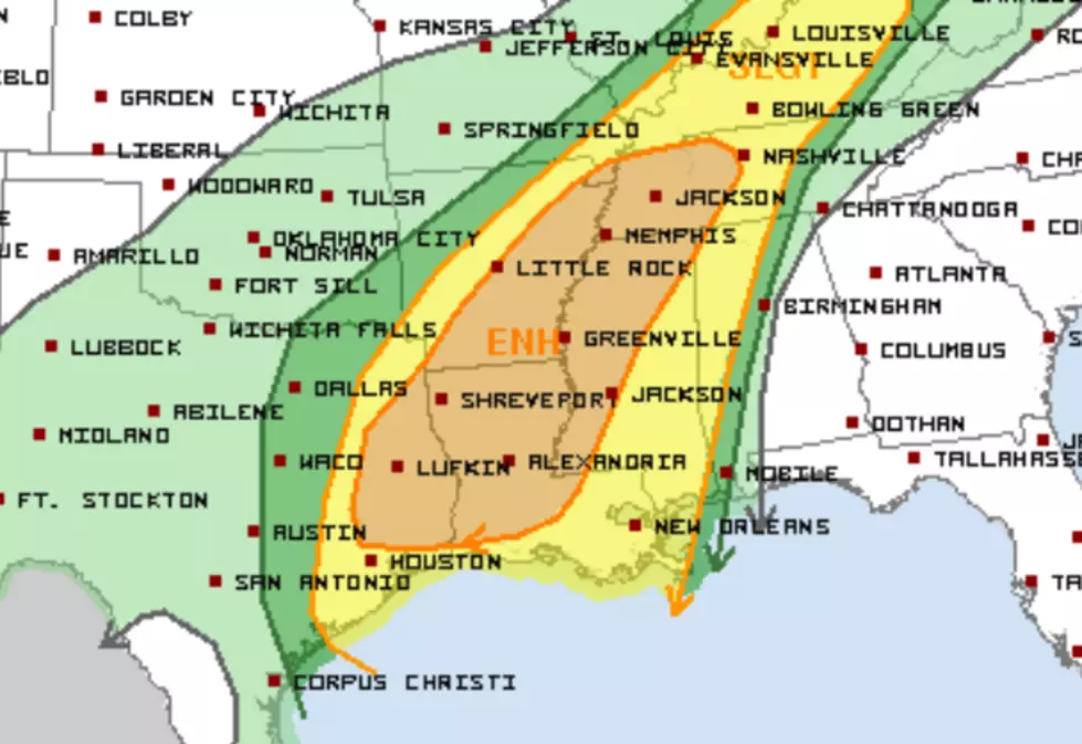
All of Deep East Texas is in the brown-shaded enhanced severe weather threat for Saturday. This breaks down to a level 3 out of 5, which means that scattered to widespread organized severe thunderstorms with varying levels of intensity will be experienced.
East Texas Tornado Threat

Lufkin, Nacogdoches, and Lake Sam Rayburn, along with the Sabine River region, are included in the yellow hatched area. This indicates the area that has the greatest risk of strong (EF2+), long-track tornadoes on Saturday.
The greatest significant tornado threat will likely be associated with any storms that can remain more discrete, ahead of the primary frontal development.
Discrete storms are supercells that form in advance of the frontal boundary squall line. They develop quickly and usually travel rapidly in a general southwest to northeast direction.
Damaging Wind Threat for the Pineywoods
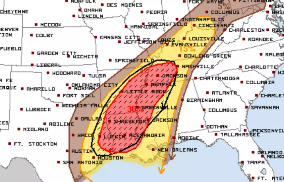
All of Deep East Texas is at risk for damaging straight-line winds associated with severe thunderstorms.
The black oval on the map above indicates an area that will have the highest risk of experiencing winds gusting to near hurricane strength (75 mph).
Hail Risk for Deep East Texas

The entirety of the Pineywoods is also included in the 'Significant Severe Weather Threat' for hail.
The hatched area shows the areas that are the most likely to have hail of at least 2 inches in diameter, about the size of a ping pong ball.
Overall Synopsis
Almost every weather model I've seen shows widespread severe storms in Deep East Texas by no later than noon on Saturday.
An inch or two of rain may fall in some areas, so there may be some isolated instances of flooding.
Much colder weather will move into the Pineywoods by Saturday night. Sunday's high temperature is expected to reach the mid-50s.
This system could bring life-threatening severe weather to our region, so please have a way to monitor weather watches and warnings.

. Have a safety plan in place should threatening weather move towards you.
10 Small Texas Towns That Are Straight Out of a Postcard
Gallery Credit: Mitch Burrow
More From Kicks 105


