URGENT: Alert Issued for Life Threatening Flooding in East Texas
The Weather Prediction Center has issued a statement warning persons in parts of the Brazos Valley and Deep East Texas of the danger of life-threatening flooding. Flash Flood Warnings are in place for much of the area, but the heavy rain has not let up and more than a foot of rain may end up falling across areas between Madisonville and Center.
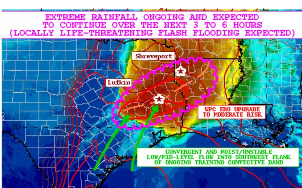
Here are some of the discussion points issued by the Weather Prediction Center:
Backbuilding and training showers and thunderstorms across southeast Texas and northwest LA are expected to continue to produce areas of extreme rainfall over the next several hours. Flash flooding will continue locally, and parts of southeast Texas in
particular are expected to see significant and locally life-threatening impacts.
The convection is situated along a well-defined outflow boundary with moderate to strong instability pooled along it which is being aided by convergent and moist low to mid-level southwest flow. This is helping to yield extremely heavy rainfall rates of as much as 2 to 4 inches/hour.
Already there have been rainfall totals locally of 4 to 8 inches in areas of southeast Texas, and with the expectation of additional extreme rainfall over the next several hours, some areas especially in between northeast Brazos, northern Grimes, northern Walker and Trinity Counties may see rainfall totals reach 8 to 12+ inches.
Significant and locally life-threatening flash flooding is expected going through
a portion of the overnight period.
Please stay home and off roadways. Severe weather still remains a possibility through the overnight hours.
More From Kicks 105


